
Full video here:
Section 4.1?
Well it was just over a year since my last visit to the TYT and I was going on another day hike – this time to the beginning of what I am calling Section 4 at Lake Alpine. The reason it had been so long was that 2023’s winter left a record-setting snow pack in its wake which wiped out much chance of a Spring hike. Then July of 2024 saw nearly four weeks straight of 100+ degree days. Between the summer heat and some major work drama, I had to cancel my plans to hike Section 3 twice.
But it wasn’t all bad news for the TYT. Over the summer I had not one but two people reach out to me regarding the trail and both had more up to date intel on the route. One, Hatch, had just hiked Section 3 the week before (we would have started on the same day!) and the second, Greg, had also hiked Section 3 before – but he had also hiked the northern half of Section 4 two years ago. He reported that the “trail” conditions on one part of Section 4 were actually worse than the infamous Section 3 route. Wow!
Fire Damage and “The Christmas Tree Farm”
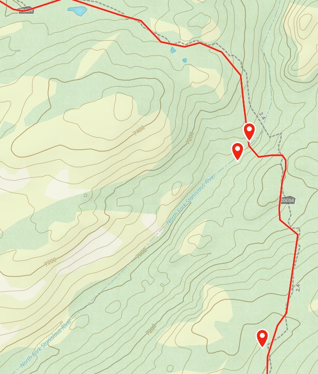
The TYT (red line and yellow highlight below) had been severely burnt by fire between Rock Lake and the Stanislaus River (red line and red highlight below) effectively wiping the trail out completely. Worse, regrowth in the burned areas now consisted of short, fluffy pine trees growing so close together that they choked everything else out. This “Christmas Tree Farm” as Greg called it was full enough and tall enough to render navigation – and even mere passage – nearly impossible.
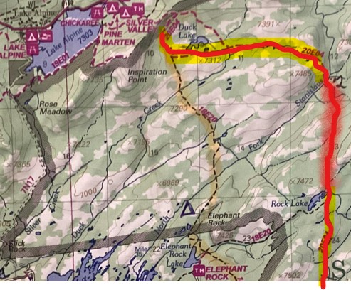
Greg recommended that I skip this segment and go around it by taking the Elephant Rock trail (18E20) down from Lake Alpine and cutting over to the TYT (20E04) at Rock Lake. So of course I wisely chose . . . to take the TYT. Ha!
My goal in this “rediscovery” section hike of the TYT was to show people what it is like today, so skipping a section was out of the question. However, I also did not want to ruin my Section 4 backpacking trip trying to hike an impassible trail. What to do?

I decided to make the first part of Section 4 a 10-mile day hike. Without a big backpack on I’d be lighter and more nimble than Greg and his buddy had been, and I’d be heading downhill instead of up like they had on their way north. If I could push through to Rock Lake, I’d cut over to Elephant Rock and back up to Lake Alpine. Then, if it was as bad as it was two years ago, I could skip that part on my Section Four backpacking trip but still have the experience of that part to share.
Lake Alpine to the Stanislaus River
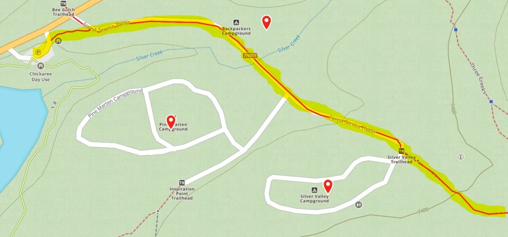
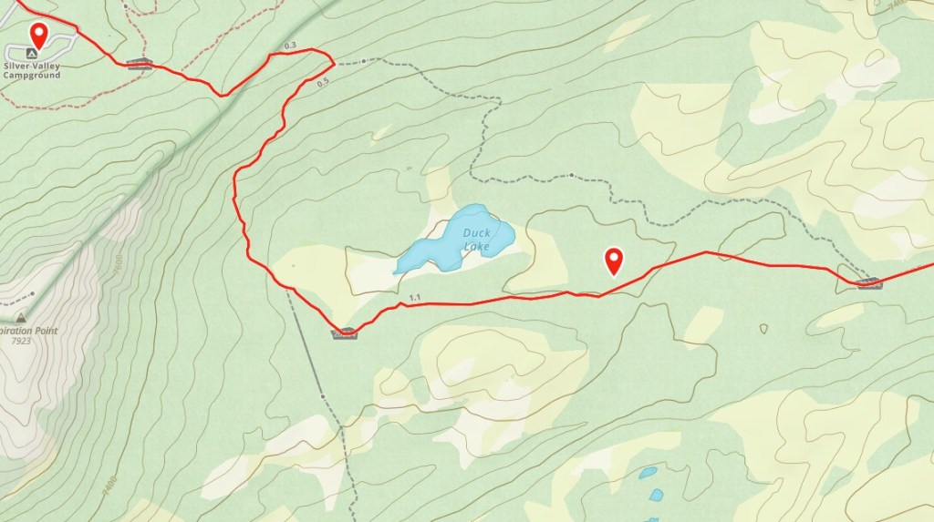
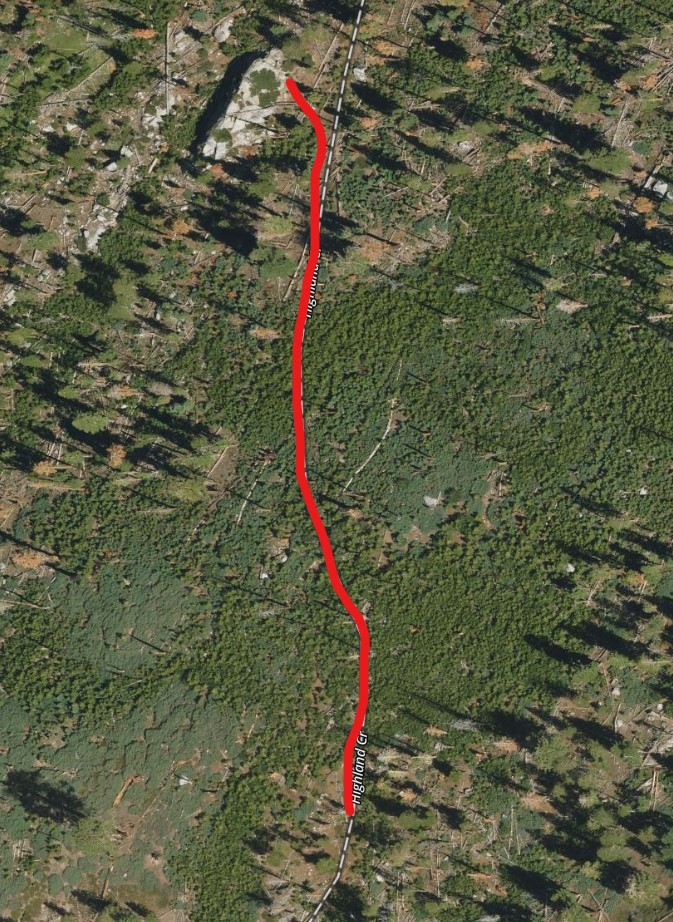
From the Lake Alpine parking lot on Hwy 4 you just follow a little path behind the restrooms to the Forest Service road (7N05Y). As you emerge onto said road, looking left you should see the Bee Gulch trail emerging right across the highway. This is the end of Section 3, turn right, and hike for about 5 minutes passing Backpacker’s Campground and crossing Silver Creek to the Silver Valley trail head near the entrance to the Silver Valley campground. You should also see a sign indicating Duck Lake and Emigrant Trail. The trail behind these signs is the Highland Creek Trail (20E04). This trail ascends about 220′ in 1.3 miles to Duck Lake.
Bypassing the TYT
Just before making a left (Eastward) turn toward Duck Lake, the Elephant Rock Trail (18E20) branches off from the Highland Creek. This is the trail you could use to bypass the problematic part of the TYT between the Stanislaus River and Rock Lake. By following the Elephant Rock Trail about 3 miles (335′ of ascent) to where it bends East to Rock Lake (another 2 miles and 900′ of elevation gain), you would meet back up with the Highland Creek Trail (the TYT) where you could turn south and continue.

I would not advise this.
As I discovered after hiking the TYT portion of the Highland Creek Trail, much of this bypass (blue line above) is every bit as difficult to navigate as the TYT which is both shorter (3.5 miles compared to 5) and less steep (685′ elevation gain compared to 1,235′).

Continuing on the TYT
Instead of taking the the Elephant Rock Trail south, continue to follow the Highland Creek Trail as it bends eastward around the south shore of Duck Lake. Soon you will see a rustic shelter that still had bed frames and some assorted pots and pans in it as of 2024. The trial does not go to the shelter but it’s a fun place to take a snack break and gaze at the beautiful Duck Lake.

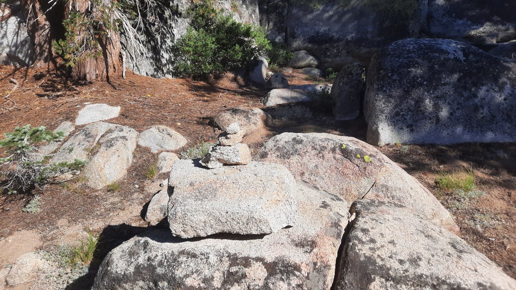
The route is pretty easy to follow until you come to a marshy meadow area a short time after passing through a fun little rocky “mini-canyon” as you head east away from Duck Lake. Once you get to the really boggy area it is time to turn south and head up onto the rocky shelf to your right. Look for a duck (rocks placed in a stack) marking the transition from meadow trail to granite deck. For the next mile or so, you will play “connect the dots” with these these ducks as you navigate across the rocky surface.
You’re now about a mile from the Stanislaus River and after some brief ascent you’ll mostly be heading downhill. The route/trail continues its gentle turn south around a 150′ tall rock mound as it descends through heavy woods in nearly a straight line. This area is not ducked but the trail, while faded in spots, is not difficult to find.
Stanislaus River Crossing
When you reach bottom, a fallen tree points to a potential crossing consisting of 3-4 rocks but it’s easy to access several other crossing points up and down from here. If you can cross at this point, the trail picks up clearly on the other side and even includes a few stone steps to get you out of the river bed.
From the river crossing you’ll ascend 375′ in 3/4 of a mile following some of the faintest trail so far. Look for blazes and look for a convenient log over a small creek along on the way. It’s about 50′ off trail to the left, but if the creek is full it makes a nice bridge. The elevation comes in two bursts, the first of about 150′ and the rest all at once to the top of a ridge where you will walk directly into the “Christmas Tree Farm.”
Navigating the (First) “Christmas Tree Farm”

Once you level out on the ridge, you will see the “Christmas Tree Farm” rising ahead of you. Don’t worry, you don’t have to enter it yet! Fortunately, there is a pretty clear route between it and the wooded forest you’ve been in for quite some time.
Keep the “Christmas Tree Farm” to your left and the regular forest to your right and look for a prominent rock rising above the trees to the left (south) of the this route once you make the corner and start heading west. This big rock is at 38.46029, -119.94813 if you want to be precise, but it’s pretty hard to miss. Circle around or scramble behind this rock to its south face. As far as I could tell from here you have to get through the Christmas Tree Farm.
About 150′ south of the Big Rock are a series of ducks that take you to a sort of path through the “Christmas Tree Farm.” Expect some fairly tight bushwhacking, but it’s more annoying than impassable. (I occasionally got on fallen tree trunks to get above it.) The good news is it’s only about a 500′ journey through the worst of it.
Navigating the Second (and Third) “Christmas Tree Farms”
Upon emerging from the thick of it, you’ll find yourself in a rocky area with more ducks. Just keep heading downhill and south whichever way seems best. Soon you’ll reach a pretty steep drop off. If you head right along its edge, it tapers down to a manageable down scramble into another “Christmas Tree Farm.” I bypassed this entirely by immediately heading left as soon as I dropped into it, then turning south once I got up on the rocks to the east of all the trees.

Shortly after bypassing this second “Christmas Tree Farm” you should be able to see Rock Lake in the distance. Unfortunately there is a third (and, thankfully, final) “Christmas Tree Farm” between you and the lake. Fortunately it can also be bypassed by sticking to the rocky eastern edge. (It is tempting to go around the western side closer to the lake, but you’ll end up doing more work than simply swinging around the eastern side and aiming for the eastern “shore” of Rock Lake.)

Rock Lake
Whether you go through or around this final “Christmas Tree Farm,” you’ll eventually emerge into older growth forest at the edge of the lake. (It can be very marshy with high grass – so watch for water when you emerge from the trees!) Enjoy the beauty of Rock Lake for a while before heading on – it’s an interesting area!

When you’re ready to continue hiking, head to the far eastern edge and pick the trail back up at its southern border. Once you return to the dirt, you’ll run into the Elephant Lake / Rock trail where it joins the Highland Creek Trail (the TYT) within just a few steps. There is a short wooden post indicating this juncture. Head left (south) to continue your hike into Section 4 of the TYT!

